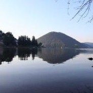
The starting point is Piediluco. Leave the Franciscan Santuary, turning right and continuing straight out of town and away from its lovely lake. Turn left (km 0.7) across the bridge, then continue left for Terni and Cascata delle Marmore. The first stretch is on asphalt along the shore of the lake. When you reach the Circolo Canottieri Piediluco 1936 boating club (km 1.47) on the left, cross the street and climb the stairs to avoid the dangerous curve. At the lot in front of the hotel, descend to the left to pick up the main road at Vocabolo Mazzelvetta. Continue straight on this busy road. After passing a house on the right, leave the asphalt road at the curve (km 2.5), following the signage on the left and passing through an opening in the guard rail. Continue along this unpaved road, skirting the fiume Velino. At the crossroads (km 3.2), continue straight past a restaurant on the right, turning left downhill by passing the guard rail. The route is very pleasant, winding between mountains and along the river. After the road block (km 5.1), continue toward the pine grove, keeping left. At the intersection (km 5.33) with the busy street, turn left and continue walking inside the guard rail. At the town of Marmore (km 6), turn right towards Vocabolo Cascata at the signage for “Cascata delle Marmore”. Walk along a building with a blue fence with white circles. At the fork near the restaurant, continue straight towards the Belvedere. Pass the Libero Liberati monument. After the campground, continue along the main road. At the lot with a grey fence on the left, enter the Parco Fluviale del Nera. Here a downhill stretch through the woods begins along an easy tractor track with short steep stretches which are not particularly difficult. Pass a masonwork bridge (km 6.8) and continue in the shade of the thick vegetation. At the bottom of the descent (km 7.25), you will reach a crossroads and continue on the level stretch to the right, leaving the road to the left behind you. The route continues level along the Valle del Fiume Nera, or Valnerina, at times skirting the river banks and at others running parallel to the river across cultivated fields. At the end of the unpaved road (km 7.8), continue along asphalt, passing an iron cross. Follow the signage for the Way, turning left at the intersection (km 8.32) and continuing along asphalt. Near the bridge–but before passing over it–,turn right along the Nera River. At the crossroads (km 10.52), continue right towards the fortified hamlet of Castel di Lago. At the town, turn left at the intersection (km 10.73) where there is a hotel to the right. After passing the town streets (km 11.13), continue along an asphalt road from where you will see Arrone in the distance. On the right, you will see the arches of the Convento di San Francesco (km 11.7). After less than 1 kilometer and an easy climb, you will reach today’s destination: Arrone (km 13).
Contatti:
IAT di Terni
Via Cassian Bon, 2-4 – 05100 Terni
Telefono: 0744423047 | Fax: 0744427259 | info@iat.terni.it
© FRANCESCO'S WAYS | Privacy Policy | Crediti
